| An Evening Flight with Doug Hartle
On Tuesday evening, June 23rd, we were driving slowly past Doug Hartle's stone house near Whiskey Point, and stopped to chat with Doug's 87-year-old mother about the duck problem in her neighborhood. Doug appeared on his small trail bike, and asked us if we'd like to go for a plane ride. It was a beautiful evening, and we couldn't say no.
On the way to Welke's Airport, he explained that he and his wife and mother had flown to Mackinac Island earlier that day, and had walked from the airport into town and part way back before exhaustion set in and they flagged down a passing horse-drawn carriage. But that trip wasn't enough to sate Doug's appetite for the sky.
Doug, a teacher from Royal Oak, became interested in flying ten years ago. He and his downstate neighbor talked themselves into buying a plane and then taking lessons. He sold his speedboat to Dan Gallagher a few years ago in order to concentrate on flying, and then bought a high performance Cessna 182 Skylane, which had belonged to Jack Hallahan and to Tom Kelso.
We lifted off an empty strip about eight o'clock, and flew over a series of clearings heading southwest. A few deer were grazing in each of the fields we passed; it was still too early for the herds to appear. Seeing the Island from above is always an exhilarating experience. This time we were thrilled at the rich shades of green below, and surprised at how many new homes have appeared on the Island's perimeter and in the woods
We flew over Fox Lake, Green's Lake, and Miller's Marsh, and then turned clockwise over French Bay. At Greenes' Bay I suggested flying over High Island, and Doug obliged. I got my first aerial view of Lake Maria, tranquil in the fading light, and the sand cliffs on its west side. As we circled the lower part, I noticed that High, like Beaver, has a central plateau surrounded by a continuous circular bluff, the footprint of a past age when Lake Michigan contained almost twice as much water.
Heading back to Beaver, we could see the Mackinac Bridge and the Northport Lighthouse. We examined the cottages of Donegal Bay and then flew over Font Lake. A solitary rowboat was anchored off its point, no doubt fishing. From our height of perhaps 600', the interconnected lily pond paddies near the southwest corner looked like an immense but docile organism, a kind of benign mass of subsurface protoplasm left over from the Pleistocene Age.
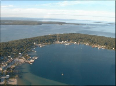
Then we looped around the harbor, marveling at the blue tones of its depths and the long, skinny arrow of wake cut into the water by the day's last arriving yacht. A second loop brought us into an approach path. We touched down, tied up the plane, and headed back to town just before nine, filled with the thoughtful excitement of having seen our home from a new perspective.
|

